


https://www.youtube.com/watch?v=kyov1bFw-aI
The latest tropical storm brewing in the Gulf of Mexico could hit New Orleans this weekend.
The Louisiana city traumatized in 2005 by the devastation of Hurricane Katrina and grappling now with an aging drainage system is in the predicted path of Tropical Storm Nate. City officials, anxious to avoid another disaster, have already begun preparing by setting up emergency generators and hastening repairs on its network of drainage pipes, canals, pumps, culverts, and catch basins.
The 14th named storm of the Atlantic hurricane season formed today (Oct. 5) near the coast of Nicaragua. Heavy rains and flooding are expected over portions of Central America, and Nate is expected to hit the gulf coast of the US as a hurricane this weekend.

Tropical Storm #Nate has formed with a notable westward forecast shift since yesterday. Check the latest forecast: http://hurricanes.gov
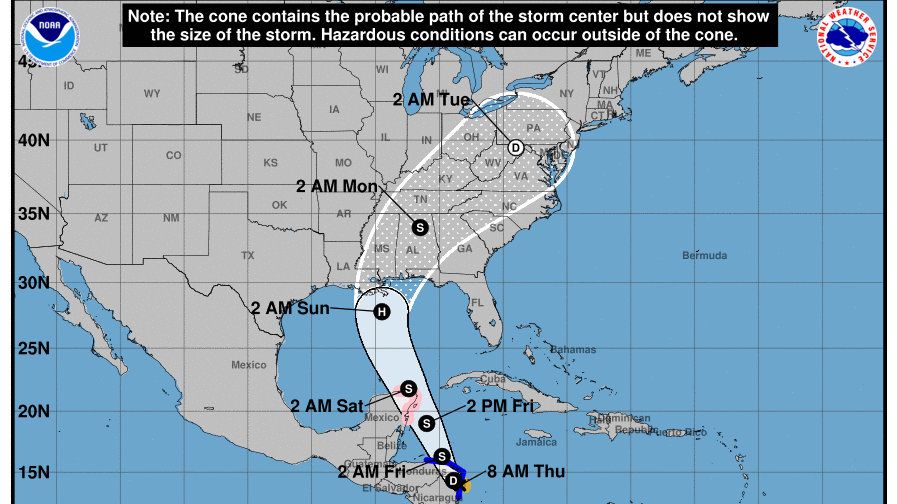
Nate was moving over northeastern Nicaragua with sustained maximum winds of 40 mph, the National Hurricane Center (NHC) said. A tropical storm warning is in effect for Sandy Bay Sirpi, Nicaragua to Punta Castilla, Honduras as well as the coast of the Yucatan Peninsula. A hurricane watch is in effect for Punta Herrero to Rio Lagartos, Mexico.
Nate is expected to strengthen significantly over the next few days, picking up speed overnight. The center of the storm should move into the Caribbean Sea tonight, and approach the coast of the Yucatan peninsula late Friday.
How the gulf coast will be affected
The forecasted path has shifted west towards Louisiana, showing Nate moving north into the Gulf of Mexico through Saturday and becoming a hurricane early Sunday, a few hundred miles south of New Orleans. It will then continue north, possibly hitting land late Sunday near the Mississippi-Alabama border as a hurricane, likely a category 1.
It’s still too early to forecast Nate’s specific timing or expected strength, especially because it will pass over land in Central America, which could affect the storm’s intensity, before moving into the Gulf. However, warmer-than-average ocean temperatures and lack of vertical wind shear means there is a strong likelihood Nate will strengthen before hitting the US coast.
The “cone of uncertainty” (the area the storm is predicted to travel based on models representing average track error over the past five years) puts New Orleans squarely in Nate’s path. Even if the storm’s eye doesn’t pass directly over New Orleans, the city will almost certainly experience tropical storm-force winds, the NHC predicts.
If history is any indication, based on the location where it first formed, there is a strong chance Nate could become a major hurricane in the Atlantic.


Named storm formation location for all Atlantic tropical cyclones during October since 1851. Western Caribbean hotspot for major #hurricanes
Track Tropical Storm Nate
You can track the progress of Tropical Storm Nate using this helpful tool from WNYC, by selecting the storm name in the top left:
Read this next: The 2017 hurricane season is on track to break the record for the most named storms

